RTK skills you should know about surveying and mapping

1. RTK base station erection skills:
1. The base station should be placed at a high place, in an open place, and there is no high-voltage line within 100 meters, and a wireless signal transmission tower such as China Unicom.
2. The base station host should ensure that it is more than 3 meters away from the top of the radio antenna to prevent interference from GPS signals and radio signals.
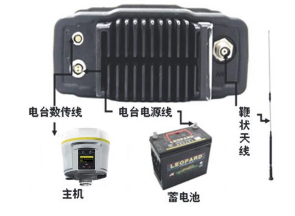
3. Ensure that the sockets of each cable are tightened, the connection sequence is correct, and finally the battery power cable is used to connect the battery, and it must be guaranteed (red to positive, black to negative). Note: When connecting, the battery is connected to the positive and negative terminals. When the work is completed, the power cord is first removed.
4. If it is rainy or sunny, cover the battery and radio with a soft bag and other items to extend the life of the radio and battery.

Figure 1: Connection diagram
2. Handbook connection skills
1 After successfully starting the base station with Bluetooth, immediately exit the geodesic program or manually change the port configuration, disconnect the Bluetooth connection normally, and then delete the COM port in the Bluetooth settings, otherwise the base station will be connected by Bluetooth. The abnormal disconnection can not transmit differential data (in today's RTK, the new WIFI hotspot connection technology has been added to solve the Bluetooth problem. For example, the Chinese test i80)
2 Pay attention to observe the working voltage of the battery displayed on the radio panel. If the maximum output voltage of the battery is less than 11 volts, the radio will not transmit normally, let alone the radio display voltage is too low; if the maximum output voltage of the battery is less than 12 volts It is necessary to switch to low power (less than 10 watts) to transmit, otherwise the radio may not work properly;
3 After the base station GPS receiving rack is good, remember not to move. If you accidentally move the position, one: if the reference value is to use the self-starting method at the unknown point, then you need to reset the local coordinates. Second: If the reference is The value is stationed at the known point by handbook, the centering needs to be re-centered, and the instrument's slant height is re-measured, and then the base station receiver is restarted with the handbook.

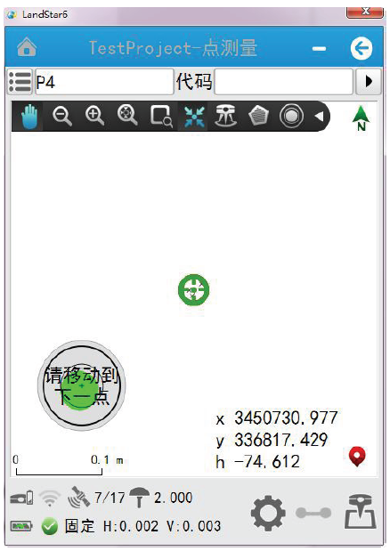
Figure 2: RTK tilt measurement interface
III. RTK point correction precautions
1 The known points are preferably distributed at the edge of the entire work area. For example, if four points are used for point correction, then the area of ​​the measurement operation is preferably inside the quadrilateral formed by the four points;
2 Be sure to avoid the linear distribution of known points. For example, if you use three known points for point correction, the triangles composed of these three points should be as close as possible to the regular triangle. If it is four points, it should be as close as possible to the square. To avoid the distribution of all known points close to a straight line, this will seriously affect the accuracy of the measurement;
3 If only horizontal coordinates are needed in the measurement task and no elevation is required, it is recommended that the user correct at least two points, but if you want to check the horizontal residual of the known points, then at least three points should be used;
4 If both horizontal and elevation are required, it is recommended that the user perform point correction with at least three points, but if the horizontal residual and vertical residual of the known point are to be checked, then at least four points need to be corrected;
5 The degree of matching between known points is also important, such as known points of GPS observations and triangular known points of the country, such as
If used at the same time, the level residual may be large when checking.
6 If there are more than 3 points for point correction, check the values ​​of horizontal residual and vertical residual to see if it meets the user's measurement accuracy requirements. If the residual is too large, the difference should not exceed 2 cm. If it is too large, Check if the input of the known point is wrong, or if the wrong point is found. If there is no error, there is a problem with the matching of the known point. It is necessary to replace the known point.
After the 7-point calibration is completed, all the coordinates measured by the mobile station are in the local plane coordinate system, and the user can directly use the measured result;
4. Reset local coordinates (emphasis)
Resetting local coordinates: It takes a few days or even longer to perform measurements and stakeouts in each survey area. To avoid repeating the point calibration every day, you can reset the local coordinates before starting the measurement work every day. The specific steps are as follows: Select a known point of the nearest point correction from the survey area (or other known points in the survey area, but you must ensure that this point is the same as the point of the point correction). A coordinate system), measure this point, select the observed control point, and save the measurement result (Note: when the point is named, do not be the same as the previous name of the point); in "File" → "Element In the Manager → Point Manager, find the known point you just measured. After selecting it, click on “Details†below, then click “Reset Local Coordinates†below, and then a “... †checkbox, click this checkbox, then find this known point (input coordinates, not the coordinates of the acquisition), then click OK, click OK, then straight Go to the software to return to the initial interface of Geodesic, and then click on the file-save task, so that the work of resetting the local coordinates is completed. Through the above operations, there is no need to re-do the calibration every day, saving time and effort.
Note: RTKs not specifically described in this article are based on the Chinese test.
We have many different kinds of square Mascara Tube.
|
MOQ |
12.000pcs |
|
Delivery time |
50-55days |
|
Material |
AS,ABS |
|
color |
Injection color,spray coating color,UV and metalizing color |
|
logo |
Silk screan and hot staping |
|
Packing |
paper carton |
|
Place of Origin |
Zhejiang |
We promise out standing service tailored to meet your demands. Our products are favored by many customers all over the world and are sold in Europe, North America, South America and Asia.
We are looking forward to your E-mail and establishing cooperative relationship with you! We would provide professional mascara tube with good services for you.
Square Mascara Tube, Square Mascara Container, Square Mascara Case
ims Packaging Limited , https://www.ims-cosmetic-packaging.com